BARANGAY INFORMATION
Location
Calawisan is situated at approximately 10.2806, 123.9357, in the island of Mactan. Elevation at these coordinates is estimated at 2.7 meters or 8.9 feet above mean sea level. It has a total land area of 9.56km².
Calawisan shares a common border with the following barangay(s):
Population by age group
According to the 2015 Census, the age group with the highest population in Calawisan is 5 to 9, with 1,321 individuals. Conversely, the age group with the lowest population is 80 and over, with 41 individuals.
Age distribution
Combining age groups together, those aged 14 and below, consisting of the young dependent population which include infants/babies, children and young adolescents/teenagers, make up an aggregate of 34.04% (3,899). Those aged 15 up to 64, roughly, the economically active population and actual or potential members of the work force, constitute a total of 63.02% (7,218). Finally, old dependent population consisting of the senior citizens, those aged 65 and over, total 2.94% (337) in all.
The computed Age Dependency Ratios mean that among the population of Calawisan, there are 54 youth dependents to every 100 of the working age population; there are 5 aged/senior citizens to every 100 of the working population; and overall, there are 59 dependents (young and old-age) to every 100 of the working population.
The median age of 24 indicates that half of the entire population of Calawisan are aged less than 24 and the other half are over the age of 24.
Population
Calawisan is a barangay in the city of Lapu-Lapu. Its population as determined by the 2024 Census was 16,821. This represented 3.38% of the total population of Lapu-Lapu. The average population growth of Barangay Calawisan(Kalawisan) is 1.6% from 2020 to 2024. Calawisan is densely populated with a significant 4,689/km². (citypopulation.de)
Households
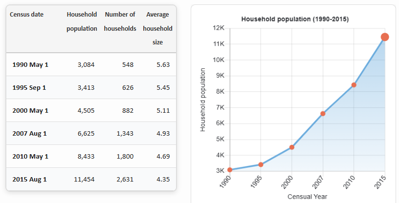
The household population of Calawisan in the 2015 Census was 11,454 broken down into 2,631 households or an average of 4.35 members per household.

BRIEF HISTORY
Kalawisan derived its name from the word “Lawis” which means a strip of land situated at the seashore and surrounded by swampy areas or marshy land.
During the post-liberation in 1944, Kalawisan was still a sitio of Brgy. Babag, Lapu-Lapu City.
In 1955, through the efforts of the late Patricio Toring who was then a Municipal Councilor of Opon, Kalawisan got its independence from being a sitio of Brgy. Babag to a separate barangay under the Municipality of Opon, now known as Lapu-Lapu City.
It has a total land area of 956 hectares, the biggest barangay in Lapu-Lapu City in terms of land area. When the RP-US Agreement materialized in 1965, US Military Units came to Mactan Airbase where residents of this barangay were employed as “tent boys”.
The Spanish regime played a vital role in the operation of barangay where its leader was then called Cabeza de Barangay and later called Teniente del Barrio and during our present time, the barangay is headed by Barangay Captain.